- MTB
- Mount Stronach
Mount Stronach
Hot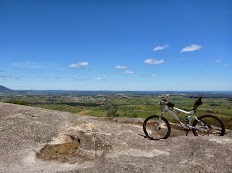
Key Statistics
Distance
8kms return (9.2kms to Trig Point)
Grade
Duration
Single Day
Time (hrs)
1-3 hours
Last Visited
November 30, 2013
Land Tenure
- State Forest
- Regional Reserve
Trail Category
Location
Mt Stronach is a great ride for cyclists with reasonable technical riding skills who enjoy their climbing and descending. You'll gain and lose up to 340 metres in altitude (or 280 metres if you only go to the end of the 4WD track rather than the trig point), but if you're confident on your bike it is worth every pedal stroke, even if you have to push your bike up the first section. It's really fun riding with a pretty nice view (and rock play area) at the top to make it all worthwhile. Having said that I'm slow and not that good a rider, and I still really enjoyed this trail, it just took me a lot longer.
There are big plans for this area in the future, but this ride just describes what's there today.
If coming in from the Bridport direction look for this turn on your left as you come into town. If coming from Lilydale, then as you come into Scottsdale you come to a T Junction and have to turn left onto Ellenor Street, if you just keep going along this road it becomes North Scottsdale Road.
Either way, reset your odomoeter at the George Street intersection and head down North Scottsdale Road. At the end of the first straight (350m) it gets a little confusing, but just continue sort of straight ahead to the right (not into the hospital) and you'll find yourself on North Scottsdale Road.
4.7kms from where you turned off George Street you will come to Jensens Road on your right (it is signed, but is a gravel road). Turn down here, reset your odometer, and drive a further 2.9kms until you come to a sweeping left turn bend in the road with a very obvious track heading straight ahead (but on the right hand side of the road) off this bend (there's some power lines overhead here if it gives you a further visual reference).
Head up this track for 200 metres until you come to what looks like an old forest landing with a bit of a track heading off to the right. The track on the right is the route up Mt Stronach.
If you've got a bit of clearance under your vehicle you can turn up onto the start of the track and there's a good parking area about 50 metres along. Otherwise just find somewhere nearby to park that is out of the way.
4WD vehicles do come through this track so whereever you park, make sure that you leave room for them to get past.
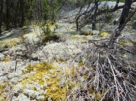
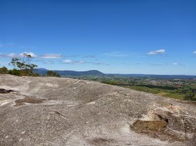
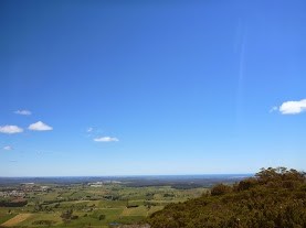
The 4WD track is about 3.8kms long and ends at a large rock look-out and if you're just here to ride this is as good a turn around point as any. You can however either drop down the back of this rock (recommended route), or follow a footpath you'll see cairned off the left hand side of the track about 50 metres before you get to this rock lookout. These two options both join up at the back of the rock and then head a further 600 metres to the top of Mount Stronach which is marked by a Trig Point.
The views from the top aren't any better than from the lookout, but although a bit more overgrown than the main track, some may enjoy the thrill of riding down this top section. There is one short bit that you will have to carry your bike up and down. Just for the record - I walked up this last bit without my bike.
Where you parked your car there are also a number of other trails that continue on around the hill and which you could explore. I have only followed the one down through the quarry (behind the gate) which comes out back out onto Jensen's Road but I suspect it would be a fun place to explore. A short ride down these trails could be a good way to warm up the lungs and legs before hitting the ride up Mount Stronach.
You could also combine this ride with the nearby Scottsdale Rail Trail ride if you want to make a big day of it.
I saw at least one snake near the top, so stay alert for our reptilian friends.
Finally, although Scottsdale is close and I had good (Telstra) phone coverage the whole way, treat this as a remote area ride and carry the appropriate gear, including a small first aid kit.
You do most of the climbing in the first 2.1kms, and don't be surprised if you find yourself pushing at least a few of these sections. I pushed about 60% of them. However after this section it flattens out a lot, and there's even a few short downhill sections as the track winds around the side of the hill. there are a few wood cutting tracks in this first section, but the main track is obvious
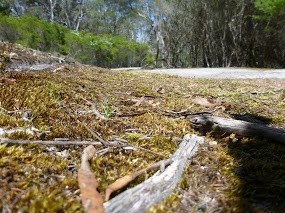
2.6kms from the start, after dipping into and out of a nice little ferny section, you'll come to your first Y junction where you should take the more obvious left hand fork up the hill.
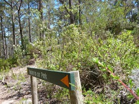
3.4kms from the start you'll come to the only other major junction where the walking track, which comes in from Buckneys Road, joins your trail from the left. There is a walking track sign here and you want to turn left at this fork and continue up the hill across some fun stone track.
There are also a few minor track forks through this section, but they're all just deviations to get around muddy sections so all roads lead to Rome.
I found the last 400 meters to the lookout an absolute delight to ride (in both directions) and it leaves you stoked as you come out onto the rocky lookout at the end.
For those that want to continue onto the trig point from here, there is a track that drops down the back of the rock you're on (if you think of the back of the rock as being behind you when looking out over the views). If you go looking for it you will find it as there are obvious tracks leading off there.
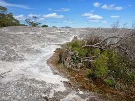
It's another steep pinch for the next 350 metres, and entirely your call if you leave your bike behind at the lookout or push it up here to enjoy the ride back down. You then have to follow the taped track up a steep section of rock which is walking only (you'd have a hard time getting your bike up here, but it's a possible carry) and then it's a fairly flat 250 metres to the trip point along lots of stone (keep your eyes out for the tapes and signs of vehicles as it is easy to lose the track up here).
The trig point and rock cairn are however unmissable ... It's just a shame you can't see much from them.
Once you've had your fill of the view, turn around and enjoy the ride back down.
There are big plans for this area in the future, but this ride just describes what's there today.
GETTING THERE
From the main street (Tasman Highway) in Scottsdale head east until you get to the T junction at the end of the road (George Street B84) and then turn left towards Bridport/Lilydale. Drive down this road for 200 metres, then take the first right onto the C832 towards North Scottsdale (signed to the Hospital).If coming in from the Bridport direction look for this turn on your left as you come into town. If coming from Lilydale, then as you come into Scottsdale you come to a T Junction and have to turn left onto Ellenor Street, if you just keep going along this road it becomes North Scottsdale Road.
Either way, reset your odomoeter at the George Street intersection and head down North Scottsdale Road. At the end of the first straight (350m) it gets a little confusing, but just continue sort of straight ahead to the right (not into the hospital) and you'll find yourself on North Scottsdale Road.
4.7kms from where you turned off George Street you will come to Jensens Road on your right (it is signed, but is a gravel road). Turn down here, reset your odometer, and drive a further 2.9kms until you come to a sweeping left turn bend in the road with a very obvious track heading straight ahead (but on the right hand side of the road) off this bend (there's some power lines overhead here if it gives you a further visual reference).
Head up this track for 200 metres until you come to what looks like an old forest landing with a bit of a track heading off to the right. The track on the right is the route up Mt Stronach.
If you've got a bit of clearance under your vehicle you can turn up onto the start of the track and there's a good parking area about 50 metres along. Otherwise just find somewhere nearby to park that is out of the way.
4WD vehicles do come through this track so whereever you park, make sure that you leave room for them to get past.
FACILITIES
None.ROUTE OPTIONS
This route follows a 4WD track, and it is still actively used by 4WD vehicles. This provides an option for those with a real 4WD (you won't get a Forester or X-Trail up this track) to do a shuttle to the top and just enjoy the ride back down, but for me half the fun was riding up knowing you get to enjoy the ride back down. Downhill riders may disagree though as there are some nice jumps and ruts coming back down this hill for those with the skills to ride them fast.The 4WD track is about 3.8kms long and ends at a large rock look-out and if you're just here to ride this is as good a turn around point as any. You can however either drop down the back of this rock (recommended route), or follow a footpath you'll see cairned off the left hand side of the track about 50 metres before you get to this rock lookout. These two options both join up at the back of the rock and then head a further 600 metres to the top of Mount Stronach which is marked by a Trig Point.
The views from the top aren't any better than from the lookout, but although a bit more overgrown than the main track, some may enjoy the thrill of riding down this top section. There is one short bit that you will have to carry your bike up and down. Just for the record - I walked up this last bit without my bike.
Where you parked your car there are also a number of other trails that continue on around the hill and which you could explore. I have only followed the one down through the quarry (behind the gate) which comes out back out onto Jensen's Road but I suspect it would be a fun place to explore. A short ride down these trails could be a good way to warm up the lungs and legs before hitting the ride up Mount Stronach.
You could also combine this ride with the nearby Scottsdale Rail Trail ride if you want to make a big day of it.
WARNINGS
Don't underestimate this ride, especially the downhill section as it would be very easy to come a cropper going down this hill.I saw at least one snake near the top, so stay alert for our reptilian friends.
Finally, although Scottsdale is close and I had good (Telstra) phone coverage the whole way, treat this as a remote area ride and carry the appropriate gear, including a small first aid kit.
ROUTE DESCRIPTION
This is a very easy trail to follow once you've made your way to the start.You do most of the climbing in the first 2.1kms, and don't be surprised if you find yourself pushing at least a few of these sections. I pushed about 60% of them. However after this section it flattens out a lot, and there's even a few short downhill sections as the track winds around the side of the hill. there are a few wood cutting tracks in this first section, but the main track is obvious
2.6kms from the start, after dipping into and out of a nice little ferny section, you'll come to your first Y junction where you should take the more obvious left hand fork up the hill.
3.4kms from the start you'll come to the only other major junction where the walking track, which comes in from Buckneys Road, joins your trail from the left. There is a walking track sign here and you want to turn left at this fork and continue up the hill across some fun stone track.
There are also a few minor track forks through this section, but they're all just deviations to get around muddy sections so all roads lead to Rome.
I found the last 400 meters to the lookout an absolute delight to ride (in both directions) and it leaves you stoked as you come out onto the rocky lookout at the end.
For those that want to continue onto the trig point from here, there is a track that drops down the back of the rock you're on (if you think of the back of the rock as being behind you when looking out over the views). If you go looking for it you will find it as there are obvious tracks leading off there.
It's another steep pinch for the next 350 metres, and entirely your call if you leave your bike behind at the lookout or push it up here to enjoy the ride back down. You then have to follow the taped track up a steep section of rock which is walking only (you'd have a hard time getting your bike up here, but it's a possible carry) and then it's a fairly flat 250 metres to the trip point along lots of stone (keep your eyes out for the tapes and signs of vehicles as it is easy to lose the track up here).
The trig point and rock cairn are however unmissable ... It's just a shame you can't see much from them.
Once you've had your fill of the view, turn around and enjoy the ride back down.
OTHER LINKS
Tassie Rambler blog visit 30 November 2013Photos


Videos

Map
Editor review
1 review
Rambler's Review
Overall rating
4.0
Fun factor
4.0
Technical challenge
3.5
Scenic/cultural/historical value
3.5
Overall rating
4.0
Review
Would you recommend?

TR
User reviews
There are no user reviews for this listing.
{{#ratings}}
{{title}}
{{#ownerCreatedBlock}}
{{/ownerCreatedBlock}}
{{#category}}
{{#editor}}
{{/editor}}
{{#user}}
{{/user}}
{{/ratings}}
-
{{#owner}}
-
{{#url}}
{{#avatarSrc}}
{{name}} {{/url}} {{^url}} {{#avatar}} {{& avatar}} {{/avatar}} {{name}} {{/url}} - {{/owner}} {{#created}}
- {{created}} {{/created}}
Category: {{category.title}}
{{/category}}
{{#fields}}
{{#showLabel}}
{{/fields}}
{{label}}:
{{/showLabel}}
{{& text}}